Services Provided
Our AMS GIS Team provides services in the following areas:
Our AMS GIS Team provides services in the following areas:
- Creation of digital maps in ArcGIS Online that can be updated live in the field.
- Creation of paper maps that show assets, physical features, and more, based on client expectations and needs.
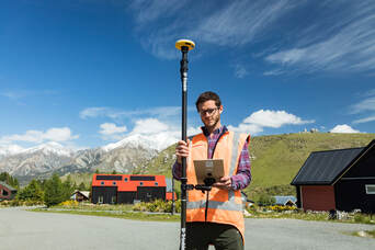
- Provide clients with survey-grade location data with our Trimble Catalyst DA2 external wireless global navigation satellite system (GNSS) receiver.
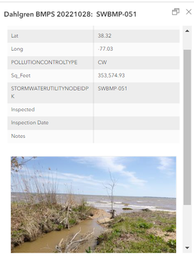
 Example of Web App use in the field.
Applications, Equipment, and Software
- ArcMap - Paper maps can be created to show assets, physical features, and other information associated with the area using client-issued GIS data and/or data collected by AMS. This software also allows field notes to be stored in the map, making it easy to read prior notes in the field.
- AGOL - ArcGIS Online (AGOL) is used as the base to create digital maps for a multitude of applications.
- Field Maps - Application used to collect and compile data live in the field. Field Maps is a digital map that is downloaded on a user's mobile device. Once the map is downloaded, the user can collect data and information live in the field with the GPS digital format. The data that has been collected can later be into an Excel file, KMZ/KML (Google Maps), Shapefile (Desktop ArcMap), or photos for easy sharing and viewing for reports.
- Web App - This application is used to create a digital copy of maps that can be accessed through a digital web link. These digital maps can be used to quickly reference certain aspects of the map (such as the size of a feature), instead of filing through a binder. The measurement tool can also be accessed in the field to measure objects or features to ensure accuracy of data.
- External GNSS Receiver - Trimble Catalyst DA2 is an external wireless global navigation satellite system (GNSS) receiver. The DA2 can connect with GPS satellites to deliver survey-grade (up to one to three centimeters) location data. The DA2 is portable, lightweight, and able to go anywhere - rain or shine.
 Trimble Catalyst DA2
The Trimble Catalyst DA2 is a tool our GIS Analysts use to collect survey- grade location data for any of our client's needs.
- Precise tool provides accuracy up to 1-3cm
- Combatable with Apple and Android Mobile devices that allows ease of use
- GPS, Galileo, GLONASS, BeiDou, QZSS, IRNSS, MSS, SBAS satellites aide location data collection
